
Home
A comprehensive resource for safe and responsible laser use
US: Lasers create light fence to protect birds in Hawaii
According to the Kaua’i Island Utility Cooperative, “The lasers are similar to common laser pointers and use a narrowly focused green beam of light. Because the beams are parallel to the ground and because the installation is not in designated air space, the lasers do not pose a hazard to aircraft or passersby.”
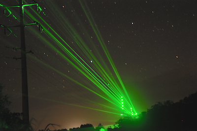
Lasers create a “light fence” to illuminate transmission poles and power lines in ‘Ele‘ele, Kaua‘i in August 2014. Kaua‘i Island Utility Cooperative is again experimenting with lasers and other devices to reduce collisions between endangered seabirds and utility equipment during the season when the seabird colonies are most active. Photo credit: Shelley Paik, Kaua‘i Island Utility Cooperative
From a press release by the Kaua’i Island Utility Cooperative (reprinted below).
US: Time-lapse video shows astronomy lasers being used at Mauna Kea
Sean Goebel, a graduate student in astrophysics, has produced a 3-minute time-lapse video showing observatories at Mauna Kea, Hawaii, shooting lasers into the night sky. By analyzing how the beam is distorted by the atmosphere, a telescope’s mirror can be counter-distorted in order to obtain sharper images for astronomers.
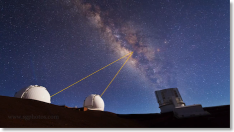
A still frame from the video. Two telescopes are simultaneously observing the same spot in the Milky Way, using lasers to help give a sharper image.
Goebel writes about the lasers:
“A typical laser pointer that you might use to point at stuff/exercise your cat is about 5 mW. That's five one-thousandths of a watt. Not a whole lot of power. And yet it's enough to blind airplane pilots. The lasers on the telescopes are in the range of 15-40 watts. The FAA calls a no-fly zone over the area when a laser is in use, and two people have to stand around outside in the freezing temperatures and watch for airplanes. Each of them has a kill switch to turn off the laser in case an airplane comes near.”
“Additionally, the telescope has to send its target list to Space Command ahead of time. Space Command then tells them not to use the laser at specific times, ostensibly to avoid blinding spy satellites. However, you could calculate the spy satellite orbits if you knew where they were at specific times, so Space Command also tells the telescope to not use the laser at random times when no satellites are overhead.”
To clarify, the FAA does not have a no-fly zone, but instead issues a “Notice to Airmen” or NOTAM about the laser operations. It is not illegal to fly over the area. Fortunately, at Mauna Kea’s location and altitude only a couple of flights per month fly at night within the laser-affected airspace over the mountain. At one telescope, planes get close enough to the beam to cause a shutoff once every year or twin.
Automated aircraft-detection systems are slowly being tested and phased in, since the cost of having humans watch the skies all night at Mauna Kea’s altitude (13,700 feet) is about $600,000 per year.
The video, “Mauna Kea Heavens”, can be seen at Sean Goebel’s website, which also has more information about adaptive optics lasers and how the video was made. Additional information on aircraft frequency and spotting techniques is courtesy Paul Stomski of the Keck Observatory. A story about Keck’s aircraft protection system appears online in Ascend magazine.
US: Laser aimed from aircraft to ground results in dozens of calls
In a September 16 2013 article, HawaiiNewsNow said there were “dozens” of inquiries about the nighttime green light. One person emailed that the aircraft circled his area about six times at 1:00 am, with a wide green laser that appeared to be scanning downward. Another email confirmed the multiple passes with a V-shaped green laser.
The Army Corps of Engineers is conducting the work. They stated that the laser is not harmful to the eyes. The Oahu work should take about a week, and mapping the entire state should conclude in November.
From HawaiiNewsNow. Similar flyovers using visible green lasers have occurred in other U.S. cities, such as New York City in 2010 and 2012, according to a a brief Google search of such reports, for example here and the comments here.